

The Highlands are easier to learn when you separate the region, the crossing you are using and the water you actually intend to reach. A marker somewhere in the area is a starting point. The next useful decision is which piece of ground connects you to your destination.
Refresh your position, find Highland in Location names, then choose one specific checkpoint and a water approach. Travel to that checkpoint before planning the next leg. Keep enough stamina and thirst in reserve to turn around.
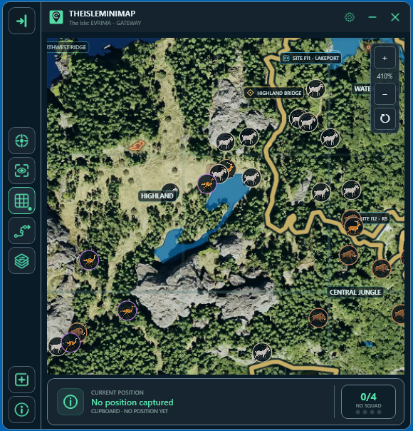
The cover is an AI-generated concept illustration, not a gameplay screenshot or an accurate layout of Highland. The map image below is an actual TheIsleMinimap screenshot.
Highland is an area; Highland Bridge is a checkpoint
Look for Highland in the app's Location names layer. This guide uses “Highlands” for that area. Keep the regional label separate from Highland Bridge, which appears in Landmarks. Arriving under a large region label does not mean you have reached the bridge or a particular shore.
| Mapped reference | What to use it for |
|---|---|
| Highland | Identify the general area you are exploring. |
| Highland Bridge | Name a particular crossing and agree on its approach. |
| Water Access | Distinguish another named region when discussing a journey between areas. |
| Central Dome | Identify a specific structure when planning a separate onward destination. |
These are reference names, not a turn-by-turn itinerary. You do not have to visit all four. Choose the one that helps with your actual journey, and compare its location with your fresh position. The broader Gateway landmarks guide explains how region names and individual structures work together.
Set up a map you can read while travelling
- Open Settings > Map Layers > General.
- Enable General layers, then turn on Location names and Landmarks.
- Add Drinking water for water planning and Roads & trails when you need route references.
- Return to the map, update your position and zoom far enough out to see your destination and the ground between it and your marker.
Begin with those references rather than every resource filter. If labels overlap, zoom or switch off a layer you do not need. You can inspect the next stretch more closely once you have chosen a direction.
Choose the shore you can reach, not just the blue shape
Before leaving a place you recognize, identify the mapped water you want to investigate and the approach you intend to use. Check where you would enter and leave the bank. A lake or river can occupy a large area on the map while the usable approach from your current side is much more specific.
On arrival, use the game to confirm the drinking interaction and watch your surroundings. A water overlay does not report whether another player is waiting nearby. If the bank is occupied or the descent is unsuitable, reassess before spending the resources you need for an alternative.
A useful habit is to choose a fallback while your thirst still gives you options. The drinking-water guide covers the interaction itself; here the important regional skill is knowing which approach your route is leading toward.
Plan an arrival and a departure differently
Arriving from the Water Access area
First confirm that your current marker is actually near the Water Access label. Then locate Highland and inspect the space between them. If your chosen approach uses Highland Bridge, make the bridge your next checkpoint and specify the side you are heading for. If it does not, choose a visible junction or other reference on the route you can verify in-game. Do not add a bridge detour simply because its name is familiar.
Leaving toward Central Dome
Use the landmark label to pick the structure rather than aiming at the centre of a broad region. Break the journey into a near checkpoint and the eventual destination. Roads and trails can help you compare alternatives, but a line on the map is not an automatic route calculation for your dinosaur.
For either journey, stop before committing to an unfamiliar drop or crossing. Check the next visible part of the terrain from a position you can leave. If the only way to continue is something your dinosaur cannot comfortably handle, backtrack to the last reference you understood. The terrain guide covers that decision in more detail.
Give friends a checkpoint and an approach
“Highland Bridge, waiting on the approach from your side” gives a friend more useful information than “I'm in Highlands.” Agree who is travelling and who is waiting. If both players keep moving toward old positions, even correct markers can create an unnecessary chase around the same area.
With Squad access, refresh each player's coordinates before deciding where to meet. You can use the shared destination pin for the agreed checkpoint. The app shows supplied positions; it does not continuously know where a player moved while Asset Location was closed. Keep verbal instructions tied to a recognizable place as well as a marker.
If the view does not match, recover one step at a time
- Update Asset Location again and check that the marker is fresh.
- Zoom out to compare Highland with the next named reference.
- Look for a landmark or route feature you can actually recognize in the game.
- Return to the last understood checkpoint if you cannot confirm the next leg.
For current map references, consult VulnonaMAP alongside the app's layers. Check official game announcements when terrain changes; an old video route may no longer match your build.
Highlands questions
Is Highland the same label as Highland Bridge?
No. Highland identifies an area; Highland Bridge is a named landmark.
Is a marked water approach guaranteed safe?
No. Check access, the drinking interaction and nearby activity in-game.
Can the minimap choose a passable route for my dinosaur?
No. Use its references to plan, then assess the terrain with your animal's movement and condition in mind.