
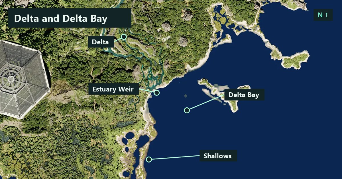
On TheIsleMinimap’s north-up Gateway map, the Delta Bay label lies southeast of the Delta label. If someone says they are “at Delta,” confirm which reference they mean before setting off. A bank, landmark or waiting point gives the next leg a clearer destination.
The map above uses the app’s original Gateway map and its built-in coordinates for Delta, Delta Bay, Estuary Weir and Shallows, checked on November 20, 2026. The callouts identify reference points. Choose your route by inspecting the live terrain as you approach.
Locate Delta and Delta Bay before choosing a route
Enable Location names in Settings > Map Layers > General and find both labels. Enable Landmarks to show Estuary Weir as another reference. Zoom out until your current marker and the relevant names fit together, then examine the next part of the journey at a closer zoom.
| Reference | Position between map labels | What to clarify |
|---|---|---|
| Delta | Northwest of Delta Bay. | Which bank or nearby feature are you using as the next stop? |
| Delta Bay | Southeast of Delta. | Which side are you approaching from, and where will you wait? |
| Estuary Weir | Southeast of Delta and northwest of Delta Bay. | Do you mean the structure or a nearby approach? |
| Shallows | Southwest of Delta Bay. | Is that the intended destination or a different place someone named? |
These directions compare the stored label positions. For a longer journey, start by locating the wider area and choose a recognisable point for the first stop. The landmarks guide explains why a structure name can be more precise than an area name when arranging a meetup.
Check which way you are approaching
Supply a fresh Asset Location reading before comparing your marker with the map labels. If you have been moving with the panel closed, your last dot may describe an earlier part of the trip. Get another update after a turn so you can see how the detour changed your approach.
Put your intended direction into the message you send to friends. For example, “I’m heading toward Delta Bay from the Delta side and will stop before the next bank.” Ask where they are approaching from too. Two nearby dots can still be separated by terrain that deserves a different route.
Use the map controls guide if zooming or panning has made the relationship hard to see. Begin with a wider view, inspect the next decision and bring your own marker back into view when you finish looking ahead.
Inspect the bank and the way back
When a route reaches water, look at the entry, the opposite side and the ground beyond the intended exit. A crossing is easier to assess when you know where you plan to stop afterward. If visibility is poor, shorten the next leg to a place you can actually inspect.
Give a friend time to reach the same decision point before making the crossing. If their animal travels differently from yours, compare the options before entering the water together. The river crossing guide goes through checking banks, reserve and alternatives.
Nearby players can change the decision while you are looking at the map. Pause somewhere you can watch the approach, then decide whether the original stop still works. If you change it, tell everyone which instruction replaces the previous one.
Set a meeting point the group can recognise
Name the area or landmark, your side and a visible feature where you will wait. If you use Estuary Weir as the reference, say whether you mean the structure or a point near it. Ask friends to confirm the same place before moving the group’s shared destination.
A destination pin can help the squad keep that chosen location in view. Player dots show each member’s latest shared position as they approach it. With Solo access, a personal pin can save a place for your own later visit. The marker guide illustrates those roles.
Match the next leg to your animal
For an animal travelling mainly on land, inspect the route back to solid ground and leave room for a detour if the entry becomes busy. For an animal using the water, look for where you can surface and where the next bank is reachable. Check your resources before extending a swim around a bend.
If you are choosing a water-based playstyle for this part of Gateway, our Deinosuchus and Beipiaosaurus comparison describes the different routines each can bring to a session. The map supplies orientation while your observations in the game determine the next move.
Make the first visit a short loop
- Find Delta and Delta Bay together with your fresh position.
- Choose one named reference or waiting point for the next leg.
- Inspect the approach and keep a familiar place available for the return.
- If playing together, agree which side to meet on and update positions before the final approach.
- After arriving, check resources and surroundings before choosing another leg.
Once you recognise the route in both directions, you can add another reference to the trip. This gives you a practical way to learn the area without needing to cross it all in one session.